- Employee Spotlight, Success Stories
- Environmental Resource Assessment & Management
Employee Owners Nominated for NOAA Gold Medal Award

Congratulations to CSS employee owners supporting NOAA’s National Centers for Coastal Ocean Science for their nomination for the NOAA Gold Medal Award! CSS employee owners have been critical members of the team charged with the rapid development of spatial models that aid in offshore wind planning in the Gulf of Mexico. The team has collected authoritative data, developed maps and spatial models, engaged with partners, and managed the project to inform siting of ocean use, environmental review, and permitting. This effort provides guidance to the Bureau of Ocean Energy Management, the agency responsible for identifying and leasing wind energy areas. This is a tremendous accomplishment that advances the President’s offshore wind energy priority and notably reduces conflict.
A big congratulations to the entire team of NOAA and CSS employee owners on this well-deserved nomination!


See More CSS Insights

Developing a Database for Ecosystem Service Models
CSS scientists have been major developers and contributors to the online U.S. Environmental Protection Agency’s EcoService Models Library (ESML) database since its inception in 2012. The ESML database contains detailed but concise descriptions of ecosystem service models to facilitate the selection of models by ecosystem scientists for a variety of management and research applications. The…

Quality Assurance Audit Reports
Since 1985 we’ve supported the National Institute of Environmental Health Sciences and have provided more than 1,600 quality assurance audit reports that the client has used to assess the quality of toxicology studies they sponsor. Over the last year our employee owners reviewed several studies involving per- and polyfluorinated substances (PFAS) compounds, or “forever chemicals”,…
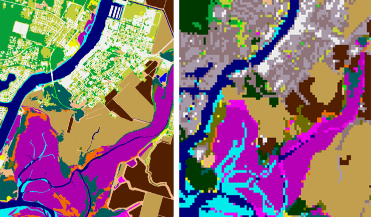
New Heavily Desired High Resolution Land Cover Data for the U.S.
The National Oceanic and Atmospheric Administration recently announced the launch of the long desired high-resolution coastal land cover data. This highly anticipated data are available for most coastal areas of the U.S., including Alaska and the U.S. territories. CSS employee owners contributed to the release of this data set by participating in production activities and…