- Success Stories, Uncategorized
- Environmental Resource Assessment & Management
Monitoring Air Quality in California’s San Joaquin Valley

CSS employee owners supported the deployment and operation of the U.S. Environmental Protection Agency (EPA) air quality monitoring trailer (WEAVE COM – Western Enhanced Air quality VEhicle for COmmunity Monitoring) in California’s San Joaquin Valley in during late fall and early winter of 2024. Elevated particulate matter (PM2.5) is frequently found throughout the valley during the wintertime when thermal inversions trap pollution. Instruments on the trailer measure criteria air pollutants, other airborne contaminants and the chemical composition of particulate matter. The mobile lab allows scientists to collect atmospheric data to fill in gaps between existing fixed air quality monitoring stations to help identify sources and types of atmospheric PM2.5. CSS staff helped set up the trailer at the deployment site, conducted daily quality control checks on multiple instruments, and supported instrument operations throughout the deployment.


See More CSS Insights

Developing a Database for Ecosystem Service Models
CSS scientists have been major developers and contributors to the online U.S. Environmental Protection Agency’s EcoService Models Library (ESML) database since its inception in 2012. The ESML database contains detailed but concise descriptions of ecosystem service models to facilitate the selection of models by ecosystem scientists for a variety of management and research applications. The…

Over 2000 River and Stream Samples Analyzed
Every five years teams supporting U.S. Environmental Protection Agency’s National Aquatic Resource Survey—consisting of tribal, state, and federal partners—collect samples from over 2000 river and stream reaches throughout the United States. CSS analytical chemists support this effort by processing the samples and then analyzing them for various chemicals to help characterize their water quality. The…
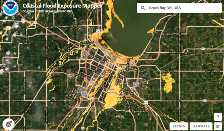
Expanding a Popular Flood Exposure Tool
We recently assisted our client, the National Oceanic and Atmospheric Administration’s (NOAA) Office for Coastal Management, with updating one of their most popular tools, the Coastal Flood Exposure Mapper.